
for Water User Associations
The italian irrigation advisory service based on satellite dataIrrisat® is a registered trademark of Ariespace srl
Advantages
Irrisat provides Water User Association managers with estimation of irrigated volume withdrawal and maps of areas that are actually irrigated.
Following the main benefits for Water Manager:
- Identifying Irrigated Areas without authorization and/or water rights;
- Reducing illicit irrigation (deterrent effect of remote control)
- Optimising field controls and in-house inspections
- Checking the irrigated volumes withdrawal (whether or not there are automatic water meters)
- Validating the operation of the water meters;
- Support for the issuance of contributions for real water consumption
- Complies with Article 3 of the D.M. MIPAAF of 31 July 2015
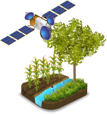
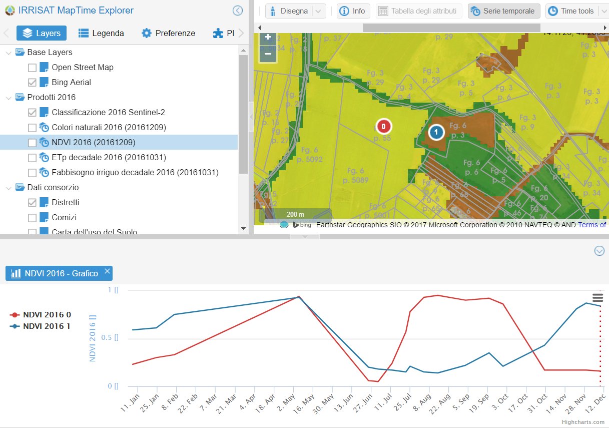
The identification of irrigated areas is based on the temporal variability of vegetative vigour retrieved by time series of satellite data. Based on a minimum number of elaborate satellite images, a classified map of irrigated crop and their growth curve can achieve. This permits verifying that the growth curve is linked to the established water suppling. The parcels with potential wrongdoing can be easily spotted by crossing the layer of the cadastral parcels, the map of actual water rights and the classified irrigated area map. On-field inspections are directed only where not complaint behaviours have been identified. The result is to reduce typical randomise inspections (we go only where non-compliant irrigation has been spotted).
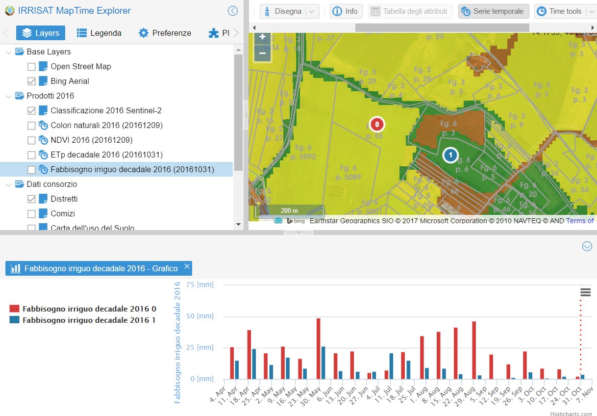
The estimation of the irrigated volume withdrawal of crops is quantified daily using the actual biophysical characteristic of the crop, such as the Albedo r, the LAI leaf area index. The time series of satellite images retrieve all this information. Satellite data acquired every five days are coupled with daily weather data into the Penman-Monteith equation, the most accepted model on a scientific basis, reported in the F.A.O. paper n.56 (Allen et al., 1998).
This approach is listed as an effective method in the “Methodology of estimating irrigated volumes (withdrawals, uses and refunds)” drawn up by the Permanent Table for quantifying irrigated volumes referred to in Art.3 of the D.M. MIPAAF of 31 July 2015 (Italian Ministry for Agriculture).
Irrisat® identifies the irrigated areas thanks to the technology developed in the project funding from the European Union’s Horizon 2020 under grant agreement No 703109
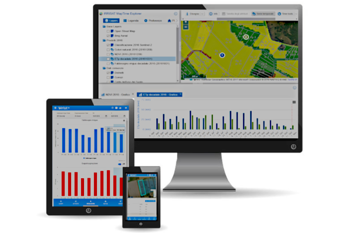
Web, tablet e smartphone
By connecting to dedicate web platform from your PC, tablet or smartphone, with simple and intuitive steps, you can consult via Web-GIS, updated maps of crop status and irrigated volumes.
Software as Service
The service, based on satellite images, can be implemented in any region of the world and is available from the web. Nothing to install, you just need an internet connection.
To Whom
Reclamation and irrigation consortia, Water User Association and water managers can obtain maps of crop irrigation needs, assess their growth, and distinguish irrigated areas from non-irrigated areas.
Do you Need more information? Contact us!
Write to us and we will be happy to give you all the information you need.
Ariespace srl
Address: Centro Direzionale IS A3 80143 Naples, Italy
Phone: +39 081 195 64 282/081 562 8563
email: commerciale@ariespace.com
Opening : 10.00 -13:30; 15.00-18, 00 MON-FRI